

e heat waves are happening with alarming regularity. Summer used to be the time for kids to be outside non-stop. Now, both children and adults need more information on how to protect their health from a wide range of pollutants in the air.
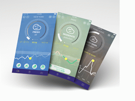
Plume Air Report is my go-to tool. There are others, but Plume is my favorite. It is available free as an iOS and Android download.
Innovator, Romain Lacombe, is the founder and CEO of Plume. He has a varied background which includes environmental economics, math, banking, a stint in Silicon Valley, and a Fulbright scholarship. Open Data, which is a key premise behind Plume, is one of his top concerns.
During the COP21 conference in Paris, Lacombe co-organized the international event "Data Against Climate Change." He believes that data can boost "climate innovation," as well as serve as an instrument of assessment and evaluation.
Equally important for Lacombe is delivering to users a drill down on pollution history for specific areas via "geolocation." This illustrates hourly shifts, and daily comparisons to annual levels. Lacombe defines this as "making the air more transparent."
Plume's World Air Map collects beyond 500,000 data points every day from 11,000 stations, in order to build "predictive models" for over 200 metro localities. For those vicinities without a station, a combination of Artificial Intelligence and data science can estimate air pollution levels on a 60-minute basis. Emissions become a concrete entity, "democratizing access to environmental information."

The map contains hexagons of different sizes and colors to demarcate city population size (from 1 million to 10 million), and city pollution (from black indicating a Plume index of +300 to two shades of blue ranging from 0-20 and 20-50). Twenty countries are listed alphabetically; 150 cities cover North and South America, Europe, and Asia.
(Note: You can view every article as one long page if you sign up as an Advocate Member, or higher).


