Roads closures and evacuations have begun for residents of La Canada Flintridge area near the Station Fire in the Angeles National Forest, in Los Angeles County.
According
to the Pasadena Star-News (9 am, 8-28-09) ├ éČ┼"At about 8 p.m. last night, the
Station Fire was 10-percent contained and had burned 500 acres. Overnight,
firefighters lost whatever containment they had and the fire has now scorched
1500 acres, spokesman with the U.S. Forest Service Gabriel Alvarez said."
There are now 750 fire personnel fighting the Station Fire, one air tanker, four helicopters and as many as sixteen engines, Alvarez said.├ éČ Ł http://www.pasadenastarnews.com/ci_13220145
1600 firefighters had been concentrating on the Morris Fire, which is now about 60% contained.
The Station fire was reported at 3:30 pm on Aug. 26, near the intersection of Hwy 2 and Hwy 210, 1.5 miles north of USFS Angeles Crest Station, hence it's name. http://cdfdata.fire.ca.gov/incidents/incidents_current
It is approximately 2 miles north of La Canada High School (normally a place where evacuees might go) , and currently covers an area about 2 miles wide and 6 miles long, according to the map at the Pasadena Star-News link above.
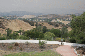
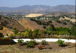
The photo above shows visibility to the north at about 3 miles, from my window, a point 6-7 miles west of the western edge of the fire. I can generally see many miles further past another set of foothills. (From my location I do not have visibility to the northeast, which is the direction of the fire, due to foothills.)
IF YOU FIND THE ELONGATED TAN DIAMOND SHAPE IN THE BOTTOM PHOTO, AND FIND ITS CORRESPONDING POSITION IN THE TOP PHOTO, YOU CAN GET AN IDEA OF LOSS OF VISIBILITY.
NOTE: I WILL CONTINUE TO POST UPDATES IN COMMENT BOXES BELOW.
(Added 8/29/09 - see current article at click here
(Added 08-31-09: See fire update, "Station Fire Claims 2 Firefighters", 18 homes at click here


