This is an update to California Fire Update: Station Fire 1:30 pm, Pacific Time 8-28-09 at http://www.opednews.com/articles/California-Fire-Update-St-by-Meryl-Ann-Butler-090828-821.html
This morning I had less visiblilty than ever, and could not see the Burbank airport out my front window, which is about 3-4 miles away, in the valley.
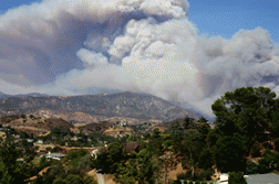
A glance past the trees in the backyard at about 3 pm Pacific Time revealed lots of smoke billowing up from the Station Fire, first reported at 3:30 pm on Aug. 26.
Helicopters and planes have been nonstop, but they look like tiny specs against the billowing smoke.
At 3:15, the LA times said, ├ éČ┼"Flames are growing closer to homes. The neighborhood north of Santa Carlotta Street in Glendale is under evacuation orders. Mandatory evacuations were ordered in the northern edges of La Ca├â ▒ada Flintridge and northwest Altadena. Flames were pushing northeast toward Big Tujunga Canyon; north to Mt. Wilson; south to Glendale; southeast toward Altadena.├ éČ Ł http://www.latimes.com/news/local/la-me-la-fire-map-html,0,7464337.htmlstory
Photos above and below are 3:30 pm, Pacific Time, Sat Aug. 29, 2009.
Photos above taken approx 6-8 miles west of the fire, which now spans an area that looks to be at least 10 miles across, according to the map at the link above. The fire area shown on today's map covers about five times the area shown on yesterday's map.
4:30 pm photos added at 4:51 pm:
(Added 08-31-09: See fire update, "Station Fire Claims 2 Firefighters", 18 homes at click here


