BACKGROUND: Last Spring Louisiana's Corne and Grand Bayou residents noticed strange bubblings in the bayou for many weeks, and they reported smelling burnt diesel fuel and sulfur. Then suddenly a sinkhole the size of three football fields appeared on Aug. 3, swallowing scores of 100-foot tall cypress trees. The sinkhole resulted from the failure of an abandoned underground brine cavern. The Department of Natural Resources issued a Declaration of Emergency on Aug. 6, and 150 families were evacuated.
For maps, diagrams and additional information, please see the previous articles in this series:
Bayou Sinkhole Site Update: Flammable Tap Water (Nov. 2, 2012) at click here
Alarming Sinkhole Continues to Cave In: Seismic Activity, Odors, Health Symptoms Reported (Oct. 30, 2012) at click here
Dangerous Levels of Radium at Corne Bayou Sinkhole (Aug. 26, 2012) at click here
Does Sudden Sinkhole Portend a Nuclear-sized Explosion? (Aug. 17, 2012) at click here
NAPOLEONVILLE, LA: At 11:50 am Central Time, on Sat. January 19, the Assumption Parish Police Jury posted on their website, "There has been increased seismic activity near the cavern this morning as well as developments of cracks on Oxy 3 pad. At approximately 10:00 this morning, another burp occurred in the sinkhole. The State Police helicopter has arrived to provide aerial viewing. Additional information will be posted as it becomes available." http://assumptionla.wordpress.com/author/assumptionla/
UPDATE added 4:49pm Eastern time: At 3:30 pm Central Time, Jan, 19, 2013, the Assumption Parish Police Jury posted this update from the DNR on their website:
The Office of Conservation, in consultation with Assumption Parish Incident Command, is advising that the Texas Brine facility sinkhole appears to be undergoing a growth event, indicated by a recent upswing in measured seismic activity that began to decrease about the time of this morning's release of debris and crude oil to the top of the sinkhole, as well as the appearance of cracks on the surface of the Oxy 3 well pad, located directly above Texas Brine's failed cavern and on the eastern side of the sinkhole.
Monitoring of seismic activity and direct field observations from ground level and overflights are part of the ongoing response to determine the potential extent of this latest growth event -- one of several observed since the formation of the sinkhole. Observations indicate that the current growth event is centered on the east side of the sinkhole -- possibly related to shifting of salt and material within the cavern collapse zone. After a period of heightened activity, the number and strength of sharp seismic events dropped markedly following the release of debris and hydrocarbons from the sinkhole -- though impacts at the surface on the eastern side of the sinkhole will continue to be monitored closely.
Following the appearance of the well pad surface cracks on the southwestern corner of the Oxy 3 well pad, the Office of Conservation advised that personnel and equipment should be removed from the site to ensure safety while observation and analysis of the growth event are ongoing.
Though the exact timing and extent of episodic growth events cannot be predicted, the Office of Conservation and its consultants had identified the Oxy 3 well pad as being within the area of potential sinkhole growth, and has maintained constant monitoring of subsurface conditions and activity for signs of instability in order to act quickly to protect the safety of the public and workers on site.(end of update.)
The most recent cave-in at the sinkhole occurred on Dec. 12, 2012, as reported on that date by the Assumption Parish Police Jury.
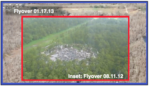
August 2012 - January 2013 Comparison Photos
This first image shows an inset of an image from the August 11, 2012, flyover, superimposed on approximately the same area of a still from the Jan. 17, 2013 flyover.

Jan. 17, 2013 flyover with August 11, 2012 flyover inset.
(Image by Assumption Parish Police Jury, used with permission) Details DMCA
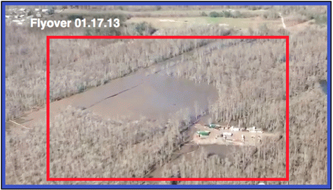
The second image shows the Jan. 17, 2013 flyover image, with the inset removed from its red frame, for comparison.

Jan. 17, 2013 flyover image, with the inset removed from its red frame
(Image by Assumption Parish Police Jury, used with permission) Details DMCA
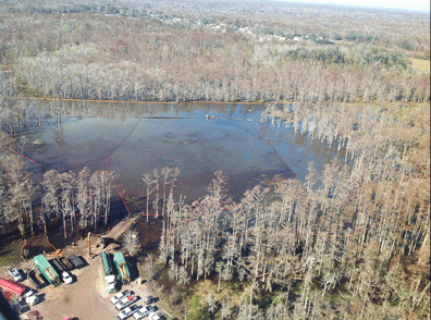
Three-Month Comparison Photos (November and August, 2012)
Photos from two flyovers, exactly three months apart, show the growth of the sinkhole over that period.

Three-Month Comparison Photos
(Image by Assumption Parish Police Jury, used with permission) Details DMCA
(Note: You can view every article as one long page if you sign up as an Advocate Member, or higher).


