Seismic activity in the GOM and the uptick in earthquakes in the
Mississippi River Basin and surrounding region
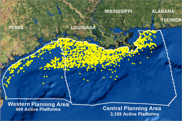
The oil and gas platforms that were in operation throughout the northern Gulf of Mexico in 2006 (per Wikipedia).
We now come to the most serious issue regarding the relentless drilling for oil and gas throughout the Gulf of Mexico. The map above clearly illustrates the density of drilling throughout the northern GOM as of 2006. Likewise, the map below demonstrates the extraordinary and increasing intensity of these very same operations off the coast of Louisiana alone.
Green lines represent active pipes (25,000 miles in all). Yellow dots represent oil rigs.
The map that follows, however, tells a story which demands the attention of every resident of the GOM coastline. The video link below the map shows the development timeline of the successively deeper wells being drilled during the last decade. Of course, with greater depths come much greater risks, as the technology and machinery have not been proportionately upgraded to accommodate the extraordinary demands and unforeseen contingencies of such a speculative and dangerous enterprise*.
*Oil and gas drilling in seawater depths of over 4000 feet, and through 15,000 to 25,000 feet of the earth's crust and mantle, is considered extremely dangerous to those from whom reason and common sense have not yet fled.
Click on the map to enlarge.
http://www.youtube.com/watch?v=bh_wNVUx9SI
It's critical to understand the location and current activity of the various faults which exist throughout the GOM and how they connect to the New Madrid Fault Line, as well as other major faults at much greater distance. There does appear to be a emerging uptick in earthquake activity in the greater Louisiana area, as well as contiguous regions in the GOM as demonstrated by unprecedented, albeit low level earthquakes. Correlations between these earthquakes/seismic activity and major operations at the Macondo Prospect have been alluded to in our previous postings.
Earthquake Activity in Gulf of Mexico Prompts 2003 Study for MMSGulf of Mexico Subsea Structures May Be in Seismic Danger Zone - Part 2
Now then, the question remains just how vulnerable has the GOM been made to a truly catastrophic event, ending up with an overwhelming displacement of water producing tidal waves, in the aftermath of an undersea earthquake.
There is no question that the ceaseless fracturing of the seafloor and fissuring of the sub-seafloor geology by the Oil & Gas Industry has set up a quite conducive environment for HUGE unintended consequences. We leave it up to the experts to conduct the necessary risk assessments, which will most assuredly let loose a sea of red flags about what Big Oil has done, and is currently doing, in the Gulf of Mexico. Furthermore, we are deeply concerned that, if a permanent moratorium on all new oil and gas drilling and extraction in the GOM is not put into place poste haste, the coastal communities will remain in a very precarious situation.
Worsening GOM predicament is reflective of the status quo around the globe.
Now consider the following scenario: that this very same predicament, which we have all witnessed in the Gulf of Mexico, is happening wherever oil and gas drilling is conducted in the various water bodies throughout the planet. Therefore we can multiply the Macondo Prospect disaster a hundred times and still not come close to the impacts that these ongoing gushers and spills, leaks and seeps are having the world over.
Perhaps the BP Gulf Oil Spill was the defining moment in modern history when all the nations of the world community were called by Mother Earth herself to begin transitioning the planet away from the Hydrocarbon Fuel Paradigm. After all, we may never get another chance!
Tom Termotto
Gulf Oil Spill Remediation Conference
Tallahassee,FL
SKYPE: Gulf_Advocate
http://oilspillsolutionsnow.org/
(Note: You can view every article as one long page if you sign up as an Advocate Member, or higher).


