Second in a three-part series
The maps. It was initially all about the maps. But it is geography that unites and divides.
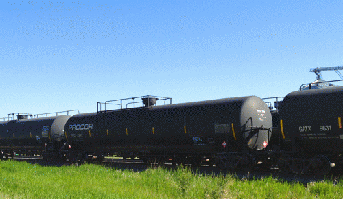
As we began our journey to investigate the proposed route of the Enbridge Sandpiper Pipeline through the Great Plains of North Dakota, we picked up US 2 in northwestern Minnesota. What Longfellow might call the remnants of the "forest primeval" hugged the gently rolling roadside--a curtain of larch, cedar, and black spruce reminding us what the Lakota and European fur traders faced as they pursued their trade routes. When the road took a slight turn north through Crookston, the blanket of forest receded and the Red River Valley welcomed us to North Dakota and expanses of flat fertile farmland stretching to the horizon. Along the way the highway hugs abandoned towns and municipalities, reservoirs, state and national parks, First Nation reservations, wildlife refuges, the National Grasslands, and the Bakken oil fields before the road becomes an afterthought in Williston. BNSF trains replaced the protective wall of forest, a constant reminder of the cargo they hauled and what Enbridge was eager to transport through the new pipeline.
Hauling crude on the plains (Photo: G. Nienaber)
The North Dakota Department of Mineral Resources reported last week that the state, home to booming oil production in the Bakken formation, became the fourth state in U.S. history to produce more than 1 million barrels of oil a day.
When the North Dakota Pipeline Company, a subsidiary of Enbridge Energy Partners, announced plans to build the Sandpiper Pipeline Project, activists in Minnesota sat up and took notice. Enbridge is a Canadian company and operates 15,795 miles of crude oil pipelines in North America.
There are 66.6 people per square mile in Minnesota, compared to 9.7 in North Dakota.
Minnesotans are very particular about their land of 10,000 lakes. North Dakota has the prairie potholes, a critical habitat for continental waterfowl breeding, but 4.1 million breeding ducks don't have much of a voice in local government.
North Dakota also has one of the largest freshwater lakes in the country, Lake Sakakawea, which was created behind a dam built in the 1940s on the Missouri River. The Northern Great Plains Aquifer System covers approximately 300,000 square miles. This aquifer system lies underneath nearly all of North and South Dakota, as well as half of Montana. It also covers nearly one third of the state of Wyoming. The Williston Basin aquifer covers much of Montana, North Dakota, South Dakota, and some parts of Canada.
That is a lot of water, but water is not a renewable resource. Much is being used in the fracking industry and parts of the watershed are under threat of contamination by oil spills if a pipeline happens to run through it. No one knows what happens when fracking wastewater is injected into deep wells under the aquifer for disposal, but the USGS recently issued a statement that warned against earthquake swarms in fracking areas. But no fracking means no oil.
The new Sandpiper Pipeline, if approved, will be 616 miles long, 24 inches in diameter, and run from Enbridge's Beaver Lodge station, south of Tioga, North Dakota to Clearbrook, MN. From there the pipeline would increase to 30 inches and deliver its cargo of Bakken crude to refineries in Superior, Wisconsin.
The Minneapolis Star Tribune published an article on an obscure pipeline spill near Bemidji, MN. In August 1979 a high-pressure 34-inch Enbridge pipeline ruptured, spilling 10,500 barrels equaling 450,000 gallons of crude. 35 years later, 100,000 gallons remain and the best anyone can do is research the effects.
It was no wonder Minnesota citizens and the First Nation are asking questions and fighting the pipeline route, which would threaten lakes, rivers and reservation wild rice beds.
But what about North Dakota?
The bulk of the new pipeline would cross the state, beginning in Tioga, ironically the location of the biggest land spill in the history of the United States in October of 2013. The 35-mile pipeline that ruptured was built by BP in 1993 and bought by Tesoro in 2001. The public was not notified until the press asked about it. In North Dakota, companies must notify the state if there is a spill, but the state does not have to release the information to the public. The federal agency overseeing spills is the Environmental Protection Agency, but they have no say unless a waterway is involved. So, the onus falls on county government, local planning commissions, journalists, and a concerned public.
But how can the public react if they have no information?
(Note: You can view every article as one long page if you sign up as an Advocate Member, or higher).


