Image: Leogane
Leogane is 25 km (16 miles) west of Haiti's capital of Port-au-Prince (a 1.5 hour drive). The reality is that Leogane is not the epicenter. The tiny village of Fayette is closest to the geographical epicenter, and residents there are very frightened by the number of after shocks and landslides they are continuing to experience. It took us about an hour to drive off-road to the village.
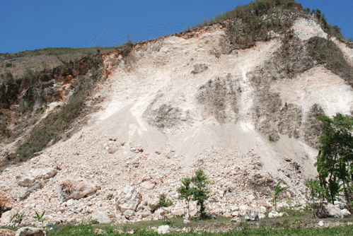
Image: Landslide near Fayette on Momance River
While Leogane is completely overrun with NGOs, Fayette gets visits from the occasional scientist, and the only camera lens focused on the village is aboard NASA's EO-1 satellite. Villagers told us they have not seen any aid workers since the quake. Nestled in fertile, natural surroundings along the Momance River, the local population is self-sufficient. They are not requesting money, food or water, but they do not want to be forgotten, either.
Steep mountains surround the valley, which is ripe with sugarcane and fruit trees. Cows, goats, donkeys, pigs and horses wander along the riverbank and stay close to the homesteads with no fencing necessary. The riverbed is both a blessing and a curse. During the dry months, the Momance looks more like a vast plain. We drove a four-wheel drive Mazda pick-up to the epicenter, using the river as a highway. It is the dry season now and what water remains did not cover our hubcaps. Women and children use stones to build small lagoons where they grow an edible plant that looks and tastes like watercress.
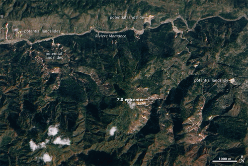
When the tropical rains come at the end of this month, this peaceful setting will become a raging torrent of water that will overflow the steep banks and eventually reach Leogane, causing flooding in the tent cities. For the villagers of Fayette, this has been an annual occurrence and something generations have learned to adapt to. Now, they are very concerned about the threat of additional landslides once the rains begin. The earthquake shifted the earth to such a degree that more landslides are inevitable near the epicenter, which can be seen in the center of this image.
The landslides on this January 15 NASA Advanced Land Imager photo are labeled. The epicenter is located at 18.457N, 72.533W. Villagers told us that during the night of March 12-13 there were at least three "shakings." The USGS monitoring stations indicated a 3.5 earthquake in the Dominican Republic around that time, although the "shakings" could have been due to additional landslides.
For reference, Fayette is at 18.489N, 72.553W.
We shot this video yesterday and edited in the field.
Fear lingers in the village. Men worry that more people will be trapped and killed by landslides when the rains come. They want some advice. There are still bodies under the rubble from the January 12 quake. People were buried when they attempted to free animals that were tethered near the hillsides. Should they move? Where? Leogane is now a tent city with little room for more. A visit to Fayette from scientists who are doing more than passing through with their instruments would be appreciated.
Looking at the larger picture, the Haitian Government says that between 200,000 and 230,000 people have been killed, 300,000 injured, and more than 1,000,000 homeless. These numbers will change over the coming months.
This article cross-posted with the LA Progressive.
(all photos and video Copyright G. Nienaber)


